Maps of the New City
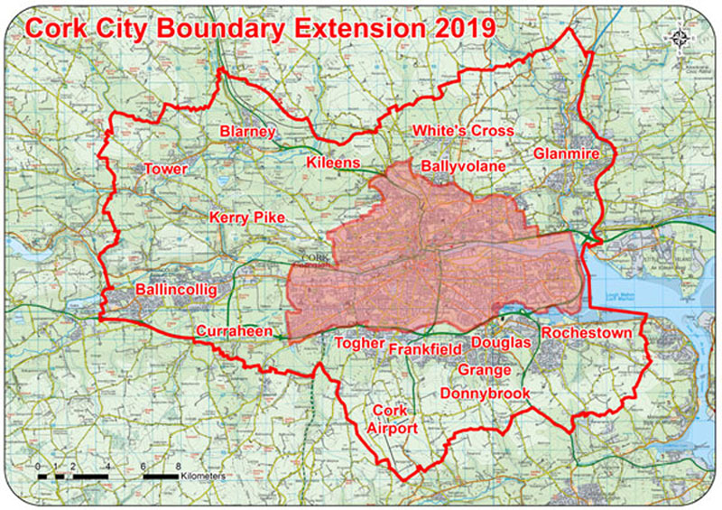
This map depicts, at a high level, the extent of the boundary extension and identifies some of the key population centres which will be transferring from the County to the City on May 31, 2019.

In addition Cork City Council is making available an interactive online map which allows residents, businesses and communities to confirm whether you will be living and/or working in the soon-to be expanded Cork City.
Users can click on the map image below and then insert their Eircode or postal address to search for their property.
The interactive map shows you:
- which ward or local electoral area (LEA) you will be voting in in the upcoming local elections
- the number of councillors to be elected in each LEA
- the population of each LEA
- Use the down arrow on the left hand side of the search function to select either an Eircode or address.
- Please use the correct Eircode format, including a space between the first three and last four characters.
- More detailed information on how to use the mapping system can be obtained by clicking the information icon
- Further layers are included which show the progressive expansion of Cork City since 1840. These are turned off by default but can be activated by using the layers tool on the toolbar at the bottom of the mapping screen.
- Further information on using the map can be found at the lower right hand side of the interactive mapping screen

Please click on the image of the map below to obtain access to the online interactive mapping tool.
Official Boundary Surveyor Maps
The provisions of Section 17 of the Local Government Act require the Boundary Surveyor to prepare maps of the revised administrative areas of Cork City and Cork County Councils as altered by the Cork boundary alteration which came into effect on the 31st of May 2019.
Section 17(6)(a) of the Act requires these maps to be published on the City Council’s website.
At the end of this page, in the “Related Files” section, links have thus been provided to the following two maps prepared by the Boundary Surveyor:
- Cork City Boundary Adjustment 2019 Adobe with seal
- Cork County Boundary Adjustment 2019 Adobe with seal
These maps can be downloaded by clicking on the appropriate link. Please note that you will require appropriate software which can read Adobe PDF files in order to be able to view the downloaded files. Also please be aware of the fact that both files are large, being 11mb and 25mb respectively.
Please find below an Adobe Acrobat PDF file which provides street level detail on the new city. Please note that this is a big file of approximately 13mb in size.


